Hardware-Agnostic and Cross-Network Universal Telematic & IoT Solutions
Advanced GPS Tracking is much more than a dot on a map ! Traksat deliver advanced M2M wireless communication solutions for GPS fleet tracking, personnel security and asset management over any kind of terrestrial and satellite network. Our interface gathers together all your assets on one screen, no matter where they operate.
Our Expertise
Cloud Abside Platform
Follow and monitor your assets on the field using our professional fleet tracking web platform and receive messages when needed with email and sms alerts. Exchange text messages and dispatch jobs with remote lone-workers and vehicles. Retrieve historic datas to generate management reports, trip summaries, or display tracks.

Global Data Network
We are official service provider for the main satellite networks with regular direct links with Thuraya, Inmarsat, Globalstar and Iridium. We also offer International simcards with voice and data cellular coverage over 160 countries at incredibly reduced roaming price. In other words, we can connect you anywhere you go on the planet.
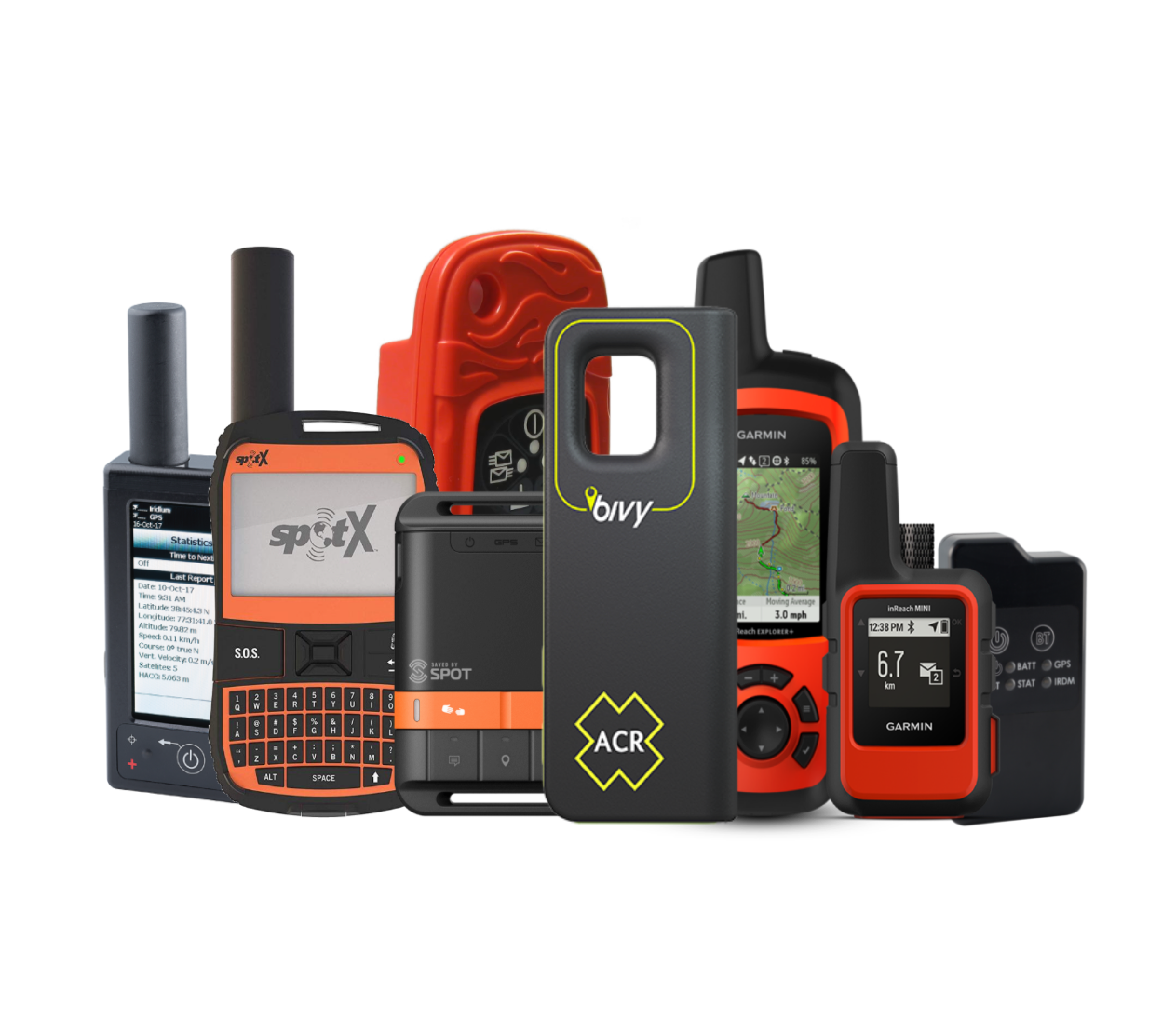
Hardware Agnostic Integration
Equip your fleet of vehicles and protect people with the latest technology. We have integrated so far nearly 160 different trackers and portable beacons communicating over any satellite, cellular, and radio networks available. We have partnered with the best proven manufacturers to provide robust and reliable hardware solutions.
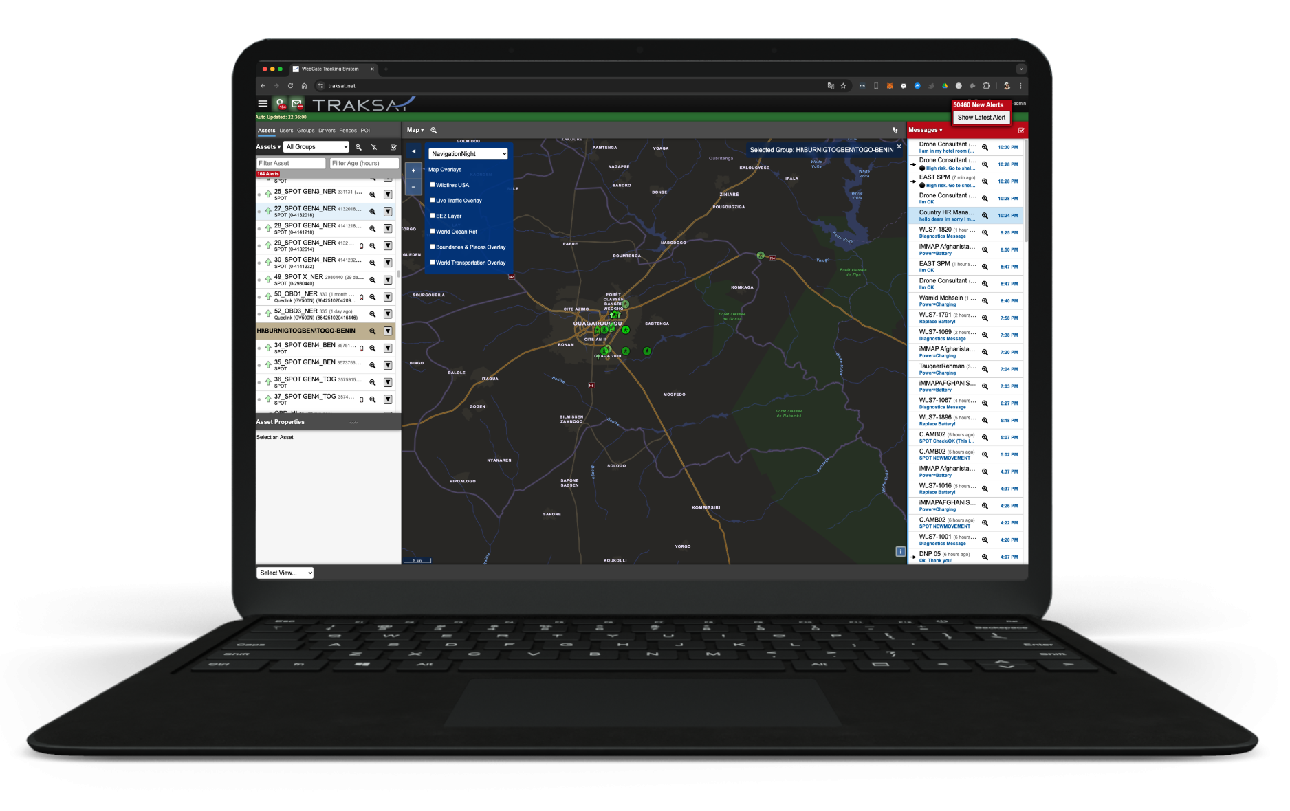
Track, Command and Control
Assets from any Web browser
Discover few key features of our solution
Geofence and POI's
Create and customize Point of Interest (P.O.I.) and multiple polygon or circle geofences. Any selected vehicle entering or leaving a fenced area will generate an alert. We provide dynamic geofencing to trigger alert when two or more moving assets are within a set distance of each other.
Tracking and Alerts
You always have real-time information for every vehicle or assets in your fleet. You can stay updated with alerts and notifications. Geofences and events help automate your workflow. Each output uses your custom rules. Easily choose what kind of events you want to be notified about.
Reporting and History
All the standard reports you need (trip and Idle, time on site, eco-driving scorecard, etc.), and as many custom reports as you want. It’s easy to get the right information to the right person at the right time. You can create custom reports for each business role and have them run on your schedule
Mapping Options
We offer a large choice of mapping options including Google Maps, ArcGIS ESRI, custom WMS feed. You can also easily export data feed to your own mapping interface using our special KML and GeoRSS outputs.
Groups and Sub-Groups
Unlimited customer groupings with complete privacy between groups. Easily create sub-groups and manage assets and users as you need between those with tailored rights and permissions for each
Emergency Alerts
High-Priority alarms handling and resolving steps management to help you apply a comprehensive acknowledgement process and setup better interactive SOS control. Alerts can be relayes by email, SMS...